Hurricane Irma… This is probably the most difficult blog post I’ve tried to write. For more than a week now, I’ve been trying to find words and without fail, I come up short. While Texas was still cleaning up from Hurricane Harvey’s visit and with wildfires burning all over California and the Pacific Northwest, a storm that would come to be named Irma started its long trek in our direction. In the end, we were so fortunate. Many of our friends, acquaintances and others we’ve never met were not. Having lived this cruising life for more than 6 years now, we have friends and acquaintances scattered about all over the place, from Maine to the Florida Keys and beyond to the islands of the Bahamas and the Caribbean. When a monster storm like Irma or Harvey, or Matthew of last season appear, our concern is not only for own safety and that of our Cheshire, but for so many others who are suddenly in harm’s way.
I can’t even begin to summarize the disaster Irma has created, in fact I won’t even try. Anyone who was watching it unfold on TV has seen the devastation. So many of the places we’ve visited in years past are just wrecked, many of them before even completely recovering from previous storms. St Mary’s GA got smacked, and our beloved St Augustine took another hard hit as well. It seems only the panhandle of Florida was spared. It’s all so overwhelming, but I think we are most heartbroken by the impact on the Florida Keys. It’s beyond description really. We’ve spent two winter seasons in the amazing community that is Boot Key Harbor and in fact had planned to return for at least part of the season this year. I can’t even begin to fathom how long their recovery will take. While the mainstream media has moved on, the recovery efforts across the state and elsewhere in the Bahamas and Caribbean are just beginning and will no doubt take years to complete. Some places will likely never fully recover.
Irma was a monster storm right out of the gate, one that maintained hurricane status for 11 days. She formed early and far to the west and left a wide path of destruction in her wake. Closer to home, she brought epic levels of storm surge to Jacksonville FL resulting in flood levels not seen since the mid 1800’s.

NWS/NOAA
While it pales in comparison to what many have experienced, I’ll try to capture a bit of our personal experience with Irma. It truly feels small and insignificant in the big picture, but because this blog is intended to capture bits of our own cruising life, I’ll give it a shot.
On Wednesday August 30, with the National Hurricane Center 11am update, Irma was declared a tropical storm. We were already starting preparations to be away for nearly a week, and began considering some extra storm prep as well. By 11am the following day (Thurs), Irma had been upgraded to hurricane status, and by 5pm that evening, was a Category 3 hurricane. This was a pretty rapid development, as most hurricanes wander a bit as lower intensity storms. We opted to take down our whole boat sun shades (which catch a lot of wind) and the jib as part of our prep.
We left bright and early Sat morning, Sept 2, for our drive to the mountains of North Carolina. We had a lovely time catching up with friends from OH, day-hiking the Blue Ridge Mountains outside of Asheville. (Blog post on the NC trip to follow.) Irma meanwhile continued to make her way across the Atlantic, with periodic fluctuations in intensity. It’s an understatment to say that we were closely monitoring her progress.
By Sunday evening, hurricane watches began to be issued for Leeward Islands. By Monday late morning, those watches were upgraded to warnings, and watches were issued for the US Virgins, the British Virgins and Puerto Rico. Before midnight, the Virgins and PR would also be upgraded to warning status. While we were enjoying our morning coffee at daybreak on Tuesday, Irma was upgraded to a Cat 5. By Wednesday morning, almost a full week after she began, Irma started tearing her way over the Leeward Islands, passing north of Puerto Rico later that night.
As originally planned, we left the mountains Thursday morning, and after a nice pause in Columbia, SC to lunch with one of my nieces, finished our drive to north Florida, witnessing an abundance of northbound evacuation traffic. We arrived at our marina with enough daylight left to do a bit more storm prep… removed the dinghy and secured it ashore and doubled/tripled some docklines. Meanwhile Irma was prompting hurricane warnings in Bahamas, storm surge/hurricane watches for south FL & the Keys while she pummeled the Turks & Caicos. The 11pm update would upgrade watches to warnings for south FL and Keys.
Friday we scurried to finish our storm prep, including removing our solar array (no small task), the blades of our wind generator, and clearing the last of covers and loose items from our hatches and the cockpit. We opted to disconnect from shore power and set switches so that only the bilge pumps were juiced as we were now on battery power (with no charging from solar or wind) only for the foreseeable future. The last thing we did was tape bits of tarp over the helm, as well as the cockpit windows and door, having learned from previous experience that even beneath the bimini, they are prone to leaking in horizontal hurricane-driven rain. Having done all we could do, we opted to evacuate ourselves, hoping our evening-into-nighttime drive would spare us some of the evacuation traffic jams. (Jacksonville was set to issue evacuation orders for our area anyway, though many stayed behind… boats float after all). As we arrived in Panama City Beach where we’d hide out at Mom’s previously empty condo, Irma was making landfall in Cuba, and was now forecasted to take a more westerly track… we swore she was following us to the panhandle.

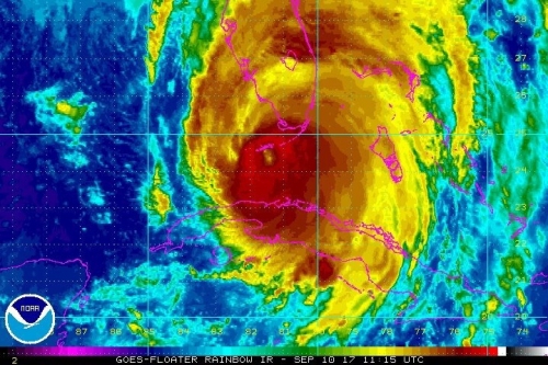
Saturday morning, Sept 9th began my obsessive monitoring of TV/social media storm coverage. By 11pm Irma was still meandering along the north coast of Cuba, setting sights on the FL Keys and west coast of FL. Hurricane warnings were in effect from Fernandina Beach around the entire Florida peninsula to Indian Pass, just 62 miles east of PCB, the whole Florida coastline save about 150 miles of the panhandle, plus the Florida Keys, Lake Okeechobee, Florida Bay, parts of Cuba and Bahamas. The satellite views and radar around this time were telling.

Irma next made landfall on Sunday morning, Sept 10, shortly after 9am as a Cat 4 on Cudjoe Key, between Key West and Marathon, but her path was wide. By mid afternoon she’d moved on to another landfall (Cat 3) near Marco Island. The flooding in the Marco Island/Naples area was significant.
Come Monday morning, Sept 11, the 8am update downgraded Irma to a mere tropical storm as she moved along the northwest coast, across the state and north into GA. This is when things started getting exciting in Jacksonville. Storm driven water being pushed into the mouth of the St Johns River met the outflow of the river, swollen from rain, resulting in epic storm surge and flooding in Jacksonville at levels not seen since the mid 1800’s. Thankfully a couple of friends who had either stayed aboard at our marina, or returned after the hurricane threat had passed, kept us posted as the water rose with the afternoon high tide. Apparently our marina was not at risk, but the next marina up river came uncomfortably close to having their floating docks float over the top of their lower-than-ours pilings, or so our fellow dock mates were warned by the Jacksonville Sheriff’s Office who were monitoring happenings along the waterfront. To my knowledge only one boat in our marina sustained damage, when a poorly anchored boat drug and ended up broadside across a couple of others on A-dock. Some cars however didn’t fare as well; the high water came fast and was a bit of a surprise, and those busy prepping boats didn’t think to move their vehicles.
Pictures tell the story better. Many thanks to dock mates, including Kareena of s/v Valhalla and Maryam of s/v Colorado for most of the high water photos. I tried to duplicate the shots later as the water receded, but the elevation change and high sun made it challenging. Still, I think you can get a feel for it. Check out the piling heights relative to things that don’t float, the ramp angles, etc.
From D-dock (ours):

view from D-dock ramp towards pergola

view from D-dock ramp, after

side view of ramp to D-dock

side view of ramp, after

D-dock piling with condo beyond

D-dock piling with condo beyond, after
From C-dock, on the way to the clubhouse:
Around the clubhouse, pool and grounds:

sidewalk to clubhouse from C-dock finger pier

sidewalk looking back towards D-dock

view of pool deck from parking lot

view from parking lot to B-dock

clubhouse entrance

view from clubhouse balcony to pool deck

view from office to pool deck
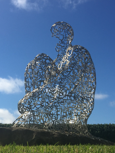
Elsewhere in Jacksonville, the Life sculpture at Memorial Park illustrates well. The shot with wave action was from a local newspaper article. The one below it is mine from a visit to the park earlier this summer. At right is the parking lot of a long-closed department store in the complex with our local Publix; note the kayaker (another shot from the local paper). Even as I write, the water is still receding about town and some are still without power. As noted before though, there are so many others who are dealing with so much more destruction. Again, we count ourselves as fortunate once again, but hurricane season is not over. Even as I type, there are three more storms brewing in the Atlantic. Here’s hoping that those who’ve already taken a hit will get a reprieve from storms still to come.

photo credit: Bruce Lipsky, Florida Times-Union
Read Full Post »


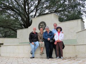
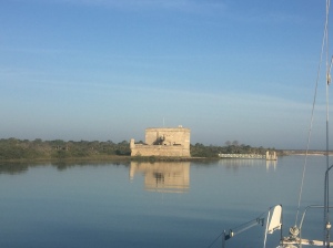 Having resolved Mike’s foot issue to the extent that it can be resolved, we pushed on to St Augustine. It’s been our habit to pause here for a bit on both our southbound and our northbound runs, but it’s always especially a treat to spend the week of my birthday in this beautiful old city. This year was no different. Actually I share my birthday week with several of our St Augustine friends, so it was a bit of a rolling celebration. Before arriving in St Augustine though, we paused for a night at one of our favorite nearby anchorages, complete with a view of Fort Matanzas.


 A few days later, some former co-workers of Mike’s came to visit, and unfortunately brought some cooler weather with them. Nevertheless, we managed to show them some of our favorite Vero spots. The


 After wandering the garden, we took a break beachside at